#MapLesotho - The benefits to Physical Planners
14 December 2014 | rusty1052
Lineo Mothae and Ithabeleng ‘Moleli are Assistant Physical Planners assigned to the Districts of Maseru and Mafeteng respectively.
[caption id=”attachment_220” align=”alignleft” width=”226”] Lineo Mothae - APP - Maseru District Council[/caption]
[caption id=”attachment_221” align=”alignright” width=”184”] Ithabeleng ‘Moleli - APP - Mafeteng District Council[/caption]
Last February was the first time our partners from Fingal County Council in Ireland introduced OSM as a tool for spatial planners. We can see a direct benefit of the spatial data being added by #MapLesotho each and every day.

Ithabeleng ‘Moleli talks about the usefulness of OSM:
OSM is used to plot information on the map for streets, sewer lines property boundaries electric, ambulance and fire extinguishers utility lines, parking spaces. Having data of this type makes it possible to carryout diverse tasks in planning; be it extension of road networks etc. OSM helps to map the situation as it is on the ground at the same time updating of maps is easier.
Lineo Mothae details her experience of using OSM for planning:
My first hand experience with using OSM was in February.As a planner in order to make a village layout, a number of factors are considered. One being the direction of growth the development is taking. Using osm makes it easier to decide where plans for for new development could be made as data on osm is accessible and up to date since it can be updated from time to time to incorporate new developments.
[caption id=”” align=”aligncenter” width=”888”]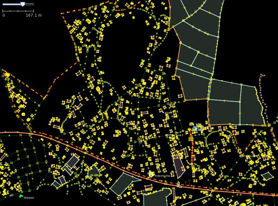 Ha’Foso - Our first area mapped in February[/caption]
OSM to me is an essential planning tool. [Mazenod](http://www.openstreetmap.org/#map=14/-29.4162/27.5442) for example, not much development was depicted of the map but now after Osm there is so much change. I have also seen it is possible to map any area, no local knowledge is required except here and there for description of land uses.
Compared to other options in the past openstreetmap is free and has a more frequent update cycle (always being updated). Planners in other countries are relying on it, and we think we should start to do the same.
Would you like to help us finish mapping Lesotho? We are currently at 76% complete. Join in today and map a tile from our mapping task. All you need is a web browser and some time!