#MapLesotho: the final visit begins
07 February 2016 | debigc
Colin, Dave and me have travelled to Maseru. At the time of writing we are still in our first 24 hours in the country. The flight was uneventful, Dublin to Frankfurt, to Johannesburg and on to Lesotho.
The country, like the two previous times I have gone is a wonder to see. Powder puff clouds and azure blue skies. Verdant plains, and striking rocky Kopje’s, complete the picture of the beautiful country we have helped to map on OpenStreetMap.
https://twitter.com/rusty1052/status/696008446198616064
We were met from the plane at Maseru by Ms. Relebohile Lebeta, who is the Commissioner of Lands in the Mountain Kingdom. She needed a briefing about the project as she is the official contact point.
[caption id=”attachment_1320” align=”aligncenter” width=”612”] Request for support October 2012 which mentions open source mapping[/caption]
With her we reviewed the original “request for assistance”, that set up the training that was delivered to the Assistant Physical Planners and Rele is one positive lady.
[caption id=”attachment_1328” align=”alignleft” width=”182”]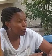 Relebohile Lebeta, Commisioner of Lands[/caption]
She gets the idea, after #MapLesotho Lesotho has opportunities that can improve its Planning functions. She fully endorses the strategy for selecting APPs who have shown enthusiasm, developed expertise and are passionate about OpenStreetMap.
#MapLesotho training begins tomorrow, Monday the 8th of February. The trainees will carry on their knowledge of openstreetmap, JOSM, QGIS, Mapillary and Wordpress, as well as developing the capacity to train/engage with others, provide technical support and flesh out the use-case for opensource mapping in Lesotho.