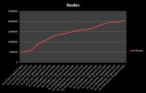
#MapLesotho hits the magical 2 million openstreetmap nodes
23 November 2014 | debigc
Sounds good, hey?
Creating a whole map of a country is a huge task. And such huge tasks have lots of landmarks along the way.
A node is created every time we click the map, putting the turn of a river, the junction of a road, or the corner of a building. A collection of nodes is a relation, so all four corners of a square building are a relation.
When the Fingal Team touched down in Lesotho in February 2014 the kingdom had just over 25,000 nodes. Most of these nodes were uploads from people who drove around the main highways and tagged a handful of significant building in Maseru. Some mapping was done near Morija outside Maseru, but little else in the countryside except for the dams, the airports and the centre placemark of the bigger towns. Now with 2,044,582 nodes the country has increased in OSM detail by a factor of 82!
Along the way we have had huge inputs from groups and individuals who are too numerous to mention. The Basotho Planners were the first to go, creating around 100,000 of the nodes in an intensive week in February and concentrating on Ha Foso. Then with the help of Dave Corley in April five #hotosm tasks were set up which easily doubled that.
Then we started using the hashtag #MapLesotho all around the world people joined in and our Polish, Canadian, German and Catalonian colleagues each contributed a big splash of edits at various times in the urban and rural tasks. The person who I need to mention, because he works regularly and consistently is our learnod G.I.S. teacher Shawn Day who trades under the OSM handle Eireidium. Also worthy of mention is Soren Johannessen who, apart from mapping, watches the OSM system stats and tweets about progress!
Soren has compared the OSM penetration in Lesotho with six similar African countries and this makes very interesting reading because it is now, rightfully, a hotbed of sustained OSM activity. The fact is if node creation is a sound measure of mapping engagement then Lesotho is now the 29th most mapped country on the planet, and the fifth most mapped African country.
The challenge we all have is to balance the short-term appeal of crisis mapping, with that of a more sustained interest in mapping a continent that lacks environmental control, and orderly physical development. All of these facts are acknowledged in the Lesotho Government’s own strategies. And we also may need to “end-run” the mapping process in some countries to show what effect creating a freely useable and re-useable store of spatial data has for African governance in planning and environmental management. That sounds lofty, but something we have the chance to prove if we continue to #MapLesotho.
